Monday, October 1, 2012

Al Okhdud (Najran)


Al Okhdood is located in the province of Najran, and estimated to be between 950 km. to 1050 km. from Riyadh.  Visitors may opt to travel by plane since a number of local air service providers are offering daily flights to Najran. Traveling to Najran requires 7 to 8 hours drive passing thru the town of Dilam, Hawtat Bani Tamim, Layla, and Sulayyil, the same road leading to the Asir provinces of Abha and Khamis Mushayt thru Wadi Dawasir. To those who wishes to continue their trip to Khamis via Najran, another route can be enjoyed passing thru Dahran Janoub. Motorists should take extra care on this route but the the sights are very rewarding.
The road to Najran was already reconstructed and widened from Riyadh until Najran, with two separate roads for each directions. Motorists are cautioned to abide by the traffic rules as a number of monitoring devices and patrol cars are positioned along the highway. Al-Okhdood is the site of an ancient city in the southern part of Saudi Arabia, founded in the 6th or 7th century BC.

The farming community survived possibly until they were annihilated by their Jewish rulers. The buildings are in ruins but still carry inscriptions and pictures. Treasures with silver coins, porcelain pottery and obelisks have also been excavated from several locations in the place.

The campaign for a place on the UNESCO list was launched after a recent article in Al-Bilad Arabic daily stressing the historical and cultural significance of Al-Okhdood and shortly taken up by bloggers. They also appealed to the Saudi Commission for Tourism and Archeology to take necessary steps.
"It is my sincere wish to include this extraordinary historical location in the UNESCO World Heritage list," said Mani Dawus, who wrote “Maria," the first historical novel based on Al-Okhdood city.  Leading Saudi intellectuals who are part of the campaign include Turki Al-Hamad, Muhammad Al-Almaei, Saeed Al-Qahtani, Ebtisam Mutawakkil and Ali Sarar.

Ali Sarar, a historian, said Al-Okhdood was the town where Christians were tortured and burned to death about 1,500 years ago.
The charred bones and thick ashes are still found at some ruins that hint at the story of the horrible religious persecutions dating back to 525 AD.

"The Al-Okhdood sites would require at least 30 years of extensive excavations to unearth its buried secrets," director of archeology in the Najran province Saleh Aal Mereah said, adding that what already had been excavated was only a fragment.
A visitor to the site first sees an encircling wall made of clay and square stones and with guard posts at the top. Inside the wall, the ruins of a huge castle are found among cleared bushes of Arak and Samar trees.

Its walls carry inscriptions, names, and engravings of animals and humans. From the top of the castle the whole city and surrounding regions could be viewed.
The story of the people of Al-Okhdood is mentioned in the chapter “Buruj” of the Holy Qur’an, which refers to a Jewish Himyarite king burning alive thousands of his citizens for converting to Christianity.
 
From The Blog Author
It is advisable to visit first Najran museum located veside Okhdud site. Here, you will be able to read the history and glanced at old pictures about Okhdud and Najran which will make your visit more fruitful. It's an unforgettable experience, each steps of every stone staircases that your feet will step in was still untouched. It was as it is thousand of years ago except for the changes made by nature as time passes by.  You will be amazed how inscriptions and early writings made thousands of years ago are preserved from the  damage of civilization and modernization. It is now here, just in front of you, written a long long long time ago.
During my visit, we are not permitted to bring any bags or back packs. One of the locals later told me that it was believed that there are lots of treasures still not yet uncovered in the site. 
 
Images taken by the author :
 
Najran Museum 


Okhdud Site
 
                                                                       Site Entrance


                                               The first Stairs to the building


                                                            Writings  on the wall


                                                    Another set of writings on the wall

The stones which makes the wall are the original stones thousands of years ago..just touching this bricks is already a history for me.....


                                                                     From The Museum


                                  The same inscriptions taken by the author at Okhdud site


Here are the latest update and project done in Al Okhdud.
(Source : Saudi Tourism website) 
 
 
Project: Excavation Works on Al Okhdood Site
Area: Najran Province

Executing agency: Antiquities Sector


The team carried out tourism readiness work at Al Okhdood Castle and its surrounding western areas. Tasks included:


Pathway created for visitors at Fed Site

  1. Arak and Thamar trees are removed from the castle site. Eradicated the roots of these trees completely, and carried them to the waste dump outside the city of Najran..
  2. Western entrance of the castle identified, its external and internal staircases cleaned and rebuilt, and castles’ outer facade identified and some disturbed stones were fixed.
  3. Cleaning and preparation of the main street leading from the west gate to the center of the castle. Drawings and carvings of some of the snakes and horses on the walls were cleared as well as cleaned up some sub-path ways.
  4. Opening of the main street needs minor attention. It is hoped that it would be possible to finish it in the next season. Thereafter tourists will be able to visit Al Okdood Castle as well as be aware of the most important evidences in the castle. Visitors will also be able to enter and exit through the eastern gate, besides site seeing the castle’s interior corridors and the mosque, which was detected in 1996.
  5. The team continued the excavations, which began since the past five seasons in the eastern side of the castle as a continuation of the earlier work. Along with the excavation work in the middle of the castle this began with the preparation of the main street and sub-entrances.


One of the excavation sits after completion

Major findings:

  • Treasure: The first ever discovered treasure first in the Arabian Peninsula through the excavations. It goes back to the era before Islam. It is a pottery jar filled with silver coins. Clear from other sources that the trove belonged to the king Qatabani (Yadi Abenif), who ruled in the second half of the first AD, as it appears on the obverse side of the coin the name of the royal palace in Tamanou, and the symbol of a local deity (Ambe) and on the back of the coin the image of the king appears. On some coins, one side shows the code and the name of the royal palace Himiry (Raydan) Dhofar, and the name of the King (Ben Amdan). It is a clear sign of confrontation as there is the name of the other kings of Himiry on some other currencies.


    Treasure: A pottery jor filled with coins found during excavation
    • Writings on metal plates: These are writings using prominent letters and these are ascribed to the southern style. One of these plates is complete while the other one is incomplete. They both speak of religiious rites and devotional issues.
      .
      A bronze place with engravings of religious practices
      • Obelisks with engravings: The most significant ones are Obelisks, which were found near a building in the center of the castle. It believed to have been a temple in the vicinity because the obelisk's writings are speaking about religious rules.


      Obelisk with writiings associated with religious practice
      • Braziers: A set of braziers were found, most of them were sculpted of granite, on its both the faces of which are written names of types of incense.
      • Pottery vessels: The found vessels are not different from the last seasons' discoveries, despite being few. They were covered with various repeating ubiquotiouis zigzag edges that featured the previous jar and pottery styles.
      • Altars: Altars are found inside a medium-sized excavation. The altar heads bear animal figures, most prominent of which was of ox-head. Some remains of blood was found on some of these altars.
      Ox head - found on the apex of an altar used for worships
      • Artistic figures: Various art figures were found. All of them were rusty metal, although these were easy to be identified, such as camels, ox head in addition to human statues.
      • Other various materials: These materials were different in terms of figures and substance, some of which were beautifully decorated items on granite plates, in addition to metal rings and ston and gypsum pieces bearing architectural decorations.


      Monday, September 17, 2012

      Hail.....The Oasis City of Nejd


      History


      The history of Hail dates back to prehistoric times passing through the pre-Islamic age and the Islamic era. It was one of the most secure sites in the Arabian Peninsula and neither Al Hîra Kings in Iraq nor the Ghassanid kings of the Levant could over take Hail until the Kingdom’s unification in 1351H (1932).

      Hail is a multi cultured province; it joins the Assyrian and Babylonian cultures as indicated in the Talmudic and Safavid inscribed on rocks and stones. These rocks and stones are considered to be important tourism attractions.

      Hail has always been associated with the famous legendary character -Hatim Altaay- who is known for his extreme generosity. Hail is also associated with the historic Hajj routes, used by pilgrims and trade caravans. Hail Province is home to many poets and literates, and was visited by many famous European explorers throughout the 19th and 20th centuries, although the access to Hail was very difficult in those days.


                                                       Hail Town as shot from A'arif Castle


      Geographic Location

      Hail is located in the center of the northern part of Saudi Arabia. It is located between the 25 and 29 degrees latitude and 38 and 42 degrees longitude. The Province is surrounded by five administrative provinces and they are: Jouf, Northern Boarders, Tabouk, Maddinah, and Qaseem.

      Hail Province is known for its strategic location since it connects the north to the north east and passengers from all over the Kingdom pass by Hail on their way to Makkah. It covers an area of approximately 11,823 square km. This is approximately 6% of the total area of the Kingdom. The Province consists of 4 major administrative centers, including three cities and Hail which is the center of the province. The Province has 66 administrative centers.


                                                 Hail Province view from top taken during a trip to
                                                 the Northern borders


      Climate


      Hail's climate is continental. Day temperatures are very warm and can reach an average of 30-34 degrees Celsius during the summer but cool down after sunset to more mild temperatures. Winter temperatures on the other hand, are very cool and decrease to 5-15 degrees Celsius during winter and may even fall to below zero temperatures. Rain falls during winter and spring. Winds drift with an average speed of 10 km/hour. Spring is the best season for visiting Hail, when the climate is mild and rainy.


      Topography


      Hail Province is known for its diverse topography as it consists of valleys, mountains, and sand and rock formations. Hail’s main topography features can be classified into: Al-Hmmad area which is known for its calcareous hills and deep valleys, Nfoud desert that covers an area of 40 thousand square kilometers, and makes up approximately 1/3 of the area, Sand formations which cover vast areas such as A`roug Almadhoor. It is located to the west of the Dahna desert, which is one of the most important grazing areas in the region and the best place for camping in the summer, and finally, Rock formations which are located to the west of Hail and cover about 1/3 of the Province. It is one of the most famous tourism sites in Hail and contain the most prominent mountains such as the mountain of Salma, Ajja, Heden, Ruman, Louf, Khashab, A`qab and other prominent mountains.


                                            A view of Hail rocks and sands from the plane captured
                                            in one of my flight to Qurayat

      Population


      Hail had a population of 260.000 people in 1394H, and increased to reach 421.100 people in 1413H and 520.000 people in 1420H, which is about 2.5% of the Kingdom’s population. More than 43% of the population lives in Hail city, where the rest are distributed around other centers and administrative areas. The population density is about 4.4 person/square kilometer, with a growing average of 2.8%. There is a great immigration movement in the Province, where large numbers of its residents moved to other provinces in the Kingdom. In 1419H 18% of Hail Province residents moved to live in other provinces, but visit Hail during school holidays and social events.


      Prayer Times


      Prayer time in Hail province is 4-20 minutes earlier than Makkah prayer time. You can check Hail’s prayer time in Um AlQurra calendar.

      Please abide by the conservative dress code followed by men and women in public places.

      Culture and Heritage


      Hail Province is the land of generosity and hospitality and the land of culture and heritage, where ever you go in Hail you can find what you are looking for. Hail contains different historic monuments of different ages and eras; these monuments include a great urban heritage represented in the unique traditional houses and palaces with attractive designs.

      Hail is also rich in traditional handicrafts and industries. Traditional souks and shops reflect the customs, believes, and traditions of Hail society that are based on the Islamic rules and regulations.

      In Hail you can enjoy traditional literature such as poetry, stories, narratives, and legendry; traditional acting arts such as the traditional dances. You can also enjoy different sports and activities such as horse riding, horse and camel racing competitions, and hunting using falcons and saluki dogs. Hail is rich with traditional clothes and jewelry, it is also rich in its traditional dishes that are famous not only in the Kingdom but in the neighboring countries as well.


                                                            Camel shepherd along Hail road


                                                      An old tower built beside the boulder


                                         Vehicles displayed along the road enroute to a town in Hail

      Nature and Environment


      Hail is rich with its beautiful natural sites represented in the mountains, deserts, and the botanical and zoological life, although animals are rare in many areas. There are some caves, craters, and beautiful plateaus with great scenery and soft breeze.

      Sports and Adventures


      Hail is famous for its diverse sports and activities related to the beautiful nature of this area, such as hiking in Ajja Mountains. Hail is also famous for hunting in different hunting seasons. Those who prefer dune driving (Tat’Ees) can enjoy Nfoud sands.


      In Hail you can practice horse riding that people of Hail are famous for, and gun firing provided that you use special shotguns licensed by the related authorities in the Kingdom. Football is also very popular in Hail as it is the number one sport in the Kingdom.
       
       
                                 Enjoying an Arabian horse ride in Hail. A rare experience for an expat... 
       
       
                                                A ladder made of steel that serves as a short cut going to 
                                                the other side of the mountain...  
       
       
      Tours and Trips
      You can reach Hail Province by air using Hail Provincial Airport that is connected to all main airports in the Kingdom, or by land using three main roads:
      1 . Riyadh-Qaseem
      2 . Ulla
            3 . Maddinah
      4 . There are other roads leading to Rafah, Northern Borders, and the Eastern Province
       
      (Reference : Saudi Tourism except all images which are owned by the author)
       
      I travelled to Hail province a number of times during my stay in the kingdom. Mostly, I traveled through the Riyadh - Qasseem highway, and I am proud to say that I am very much familiar with this route.
       
      Here are the historical and heritage sites that I visited while in Hail :

      A’arif Port
      A'arif Fort is located in Hail City, one of the province located in the Northern part of Saudi Arabia, and around 650 Km. from Riyadh. Driving to this city took us 6 hours passing to the province of Buraydah and Unayzah city. In case you opted for an air trip..it will be around an hour trip only from Riyadh.
      The historic fort of A'arif is said to be built at the end of 11th century Hejra and the beginning of 12th century Hejra. The fort was first built with mud and clay, rectangular in shape and around 40m x 11m in size. It was built to protect and also as a defense for the city.
      The first construction of the fortress was made during the reign of the Al-Ali family at the end of the 11th Hijra century (17th century AD) and the additions and annexes were made to it during the rule of the Al-Rasheed family. During the Saudi rule, the fortress was used for the sighting of the Ramadan moon and for firing of the Iftar gun.
      Built on a mountain peak, the fortress could be seen from anywhere in Hail
      Taking pictures of the fort is only allowed after securing approval from the caretaker.
       
       
      Uraif Castle View


      Uraif Castle view from the gate
       
       
      Uraif Castle stairs


      Al Qishlah Palace
      Al Qashla building architectural style represents one of the most attractive areas of urban heritage. Al Qishlah were built in 1362H during the reign of King Abdul Aziz to be used as a military barrack. Al Qishlah is a two storey building which is built by combinations of clay, stone, and wood according to architectural style known in Najd area. The palace has two large gates at the east and south sides. There is a total of 142 rooms in the building which faces the internal yard. At the center, there is a mosque with uncovered praying area and basement.
       

                                               Al Qishla palace as shot from the palace yard


                                               Ground floor view from the second floor


                                                                   Palace visitor rest area


                                                A view of the palace wall and the old car


                                                                               Palace rooms


                                               Old card displayed at the palace grounds


      Monday, September 3, 2012

      Magnificent Farasan - (Farasan Island - Jizan)


      Farasan Island Beach below the bridge linking the two largest island
      
       
      BACKGROUND AND OTHER INFORMATION
       
                                                                                                                                                                       
      The Farasan Bank is a coral shoal 100km wide that stretches 800km down Saudi Arabia's Red Sea coast. It lies 40km from Jizan and takes about 90 minutes to get there by ferry.
       
      The islands were created more than 8000 years ago at the end of the last ice age. Conditions here are perfect for the growth of coral, which has spread through the area, creating a rich and beautiful ecosystem.
      The archipelago includes two large islands connected by a bridge, Farasan Kebir and Segid.
      5,000 people live on the largest island, Farasan in Farasan Kebir and Segid. The only other island with a permanent population is Qummah.
      Continuously manned coastguard stations are on the main island as well as Zifaf and Rumain. Kutambil Island northwest of Shuqaiq is a volcanic island situated 5 km offshore. The 100m peak of volcanic clinker dominates the island. The south and southeast parts of the island are flat and sandy. Rich coral reefs lie offshore.
      The Farasan Islands are largely low, flat-topped lumps of coral that are barely a few meters above the water. The beaches are made of dead coral, and can vary from smooth white beaches to quite rough sand. On the smaller islands, there are virtually no beaches at all.
      Bird life is plentiful and at different times includes Spoonbill, Western Reef Egret, Striated Heron, Osprey Sooty Falcons, Pink-Backed Pelican, Red-Billed Tropik Bird, White-Eyed Gull, Saunders Little Tern, Crab Plover and Flamingos.
      To find the ethereal, other-world beauty of the Farasan Islands, it is necessary to put your head underwater where a world of colorful coral reefs, flying rays, dolphins, dugong, sea turtles and whale sharks opens below you. This some of the most awesome underwater diving in the world.
      The Farasan Islands are an unpretentious wonderland. Nature in its simple best. Farasan Hotel is the only hotel on the island and accommodation is limited, so it's necessary to book. The hotel can arrange land tours, overnight guided sea trips, fishing, snorkeling and deep sea diving for the accredited diver.
       (Reference ; Saudi Tourism Website)
       
      Traveling To Farasan Island
       
      I recommend visiting Farasan island with your car. As soon as you arrive in Farasan, there are no rent a car or public transportation except for private cars offering personal services for touring the island or traveling to the town center.
      Two ships are engaged in the service. One leaves Jizan Port at 7.00AM and the next at 3.00PM. Almost at the same time two ships leave the shore of Farasan to Jizan


      The ticket of Ship is free of Cost. This ship carries 35-40 cars and The flukas are also used on this route which accommodate more than 60 people. With the arrival of a new ship in 2006, the travel time between Jizan and Farasan was improved from 3 hours to 1.5 hours.
      The Saudi Government Replaced the old ships with 2 new temporary faster and larger ferryboats, the journey takes about 90 to 120 minutes and 2 trips daily each way

      Ship Schedule

      Farasan-Jizan 7:00 am Farasan-Jizan 3:00 pm
      Jizan-Farasan 7:00 am Farasan-Jizan 3:00 pm
       

      Although the ship leaves Jizan port at 7:00 am, It is a must that the traveler be at the port no later than 5 am in order to reserve a ticket. There's a parking space with limited capacity in the port in case you decided to travel without your car. If you decided to bring the car, which is highly recommended, you must be at the port earlier than 5 am since there are lots of cars falling in line as early as 1 am carrying goods to be sold and delivered to Farasan. In most cases, including cars loaded with construction materials since all the basic needs including fuels are all coming from Jizan.
       
      On weekends, it is quite hard to get a ticket, so you have to fall in line much earlier than 5 am. In case you failed to get a pass from the Customs, you can avoid frustrations by renting fluka (small boats)
       
      The flukas are also used on this route.This flukas carry up to 12 passengers. The ticket price is SR50 per person each way . The fluka take 1hour on this route, there is no fixed schedule for this kind of transportation, it can be hired at any time as long as you pay the cost of the minimum number of the passengers which is 6 or SR 300
       
      As soon as you arrived in Farasan, you have to proceed immediately to the customs office in the town center to reserve your return ticket to Jizan, that is, if you would like to return in the afternoon or the following morning.
       
      Camping out along the seashore or under the bridge is the best way to experience Farasan. Saudi coast guard patrols the sea shores to provide safety to the visitors. While camping, you can enjoy fishing, if you're lucky enough, you might have a glimpse of gazelles passing by along the coast line.
       
      STC installed transmission lines providing internet, land line and GSM line services in the island.
       
      During my visit, I was surprised to find a lot of expatriates fishing along the coastline of the famous Farasan bridge. The Vietnamese nationals in the island is almost equal in numbers with the Filipinos.
       
      Stingrays and colorful fish are normal sites along the sea shores.
       
      An article from Oasis Magazine describe Farasan island as a gift to nature lovers with a freebies of heritage and historical sites :
       
      "There is as much reef in the Farasan Islands as there is along the entire coastline of Saudi Arabia. As such, this makes the Farasan Island is one of the most attractive and popular diving spots in Saudi Arabia and a favorite destination for Saudis and international visitors. Fauna of the Farasan Island include 231 species of fish, 49 species of reef building coral, 3 species of Dolphin, crustaceans, large numbers of breeding seabirds as well as populations of breeding Ospreys (Pandion Haliaetus) and Sooty Falcons. A remnant population of endangered Dugong and the only known confirmed breeding site for Crab Plover (Dromas Ardeola) on the Red Sea coast of Arabia are protected on Farasan Island.
      In addition, the Farasan Island is home to the special nature reserve, which was established in 1989. It is overseen and mandated by the National Commission for Wildlife Conservation and Development. As a result of the protected status of the nature reserve, the Farasan Island now holds the largest gazelle population in Saudi Arabia. On the main island there are more than 500 gazelles, which roam freely. Can you imagine the photo opportunities?! For land lovers, this article would not be complete without mentioning that the Faifa Mountains merit a trip for the opportunity to see some unique rock formations and lush green meadows in Saudi Arabia. And for those who enjoy history, a smaller island not far from the main Farasan Island holds the ruins of an old German-built Fort used during World War II. It is said that this fort had been a secret storage location for ammunition during the war"


      Hotels and Restaurants
       
      During my visit last February 2012, I found two hotels serving the island visitors, Farasan Hotel located in the town proper and Coral Hotel, a 5-star hotel located before entering the town, and along the sea shore.
       
      Aside from the hotel, there are very few restaurants in Farasan. I have identified only three small restaurants offering roasted chicken and kabsa. Canned drinks and other grocery items are expensive in the island, the reason why other visitors bring their car loaded with groceries from Jizan Panda.


      A view of Islands from Farasan bridge


      Posing along the wall of an Old Ottoman Fort at the background


       A fish bone from a very huge fish that was washed out in shore few years back. The fish believed to be from whale family


                                                          The famous Farasan Island bridge 


                                                            Posing along the Farasan bridge


                                                                              Boats for hire


       `
       
       
      While in Saudi Arabia....Try Visiting and Exploring Farasan......An opportunity you should not miss......


      Friday, August 31, 2012

      Exploring the province of Al Jouf (Northern Borders)


                                    Sakakah..The capital of Al Jouf Province..view from Qasr Za'abal


      Al Jouf Province is located around 1100 kms. from Riyadh and is the gateway to the Northern borders. I have been traveling from Riyadh to this province  by land in the past three years, and in my experience, there are two (2) routes to choose and enjoy. Each route offers amazing sceneries and adventure.

      The first route passes to the province of Majmaa, Zulfi, Buraydah, Hail, and the last portion, which is the most exciting part, experience driving to around 320 to 350 kms. of sand dunes. You will be amazed with the beauty of this desert specially during winter where the sun's ray adds color to the huge sand dunes and the appearance of clouds, if you are lucky enough, will make you stop and enjoy the scenery. The bad news of this route? There's no gasoline station along the highway for the whole route, this information is true as of February 2012, during my last visit in the Northern Border provinces. Now for the good news, as of February 2012, there's a small store managed by one of the  railway worker. Here you will find cold water and sodas, energy drinks, biscuits and hot cup noodles. The store opens at 4:30 am and closes at 12:00 midnight. Although closed, this store serves as a parking area for some travelers and trailer drivers. The end of the highway leads you to a small village and the first gas station on the right side of the highway. To go to Domat Al Jandal, Sakakah, Jouf airport, and Arar, take the exit before the bridge. Traffic sign is available and written in both Arabic and English to guide motorists traveling to Al Jouf.


                                               Posing along Hail - Jouf  Desert


      Here are some of the images taken along the Route 1 :


      The second route passes to Majmaa town proper. From the Riyadh - Qassim highway, take the first exit going to Majmaa town proper. Follow the sign and route to Hafr Al Batin and Kuwait. Hafr Al batin is around 400 km. from Majmaa. You will then pass thru Rafha and Arar. From Arar, take the route to Al Jouf. Al Jouf is around 150 km. from Arar. Opting to go on this route, you have to travel around 1200 km. from Riyadh. The good news? Since this is the old route from Northern Border provinces to Riyadh, Eastern Region, Kuwait, and Emirates, gasoline stations, hotels, and stores can be found along the main highway in every town and villages. Now, for the bad news...the road is already old but still passable and up to this time, was still the main route from Northern region to Eastern region, Kuwait and Emirates. Travelers along this route are cautioned and alerted  at all times since desert kings (camels), sometimes in groups, crosses the highway even at night. This is some of the images caught during my trip passing through this route 2 years ago....


      Camel shepherd along Majmaa - Hafr Batin road


                                                             Herds of Camels along the highway


       The owner


       Another group of camels spotted along Majmaa - Hafr Al Batin highway


      Al Jouf offers a number of Historical and Heritage sites to the visitors. It is again advisable to explore this sites in the cold season since Al Jouf temperature is usually hot and dry from May to the month of September.


      Domat Al Jandal

      After four (4) hours of continous drive and with almost no fuel left, I finally arrived in the first  village of Al Jouf province...Domat Al Jandal. As you approach the town center, around 20 - 25 km. from the main highway, you will find a red signboard with Saudi Tourism Logo (SCTA). mentioning  Domat's heritage and cultural pride. All sites can be found easily since they are mostly located within the town proper. Omar Bin Al Khattab Mosque, Domat Museum, and Qasr Marid are located within city center.


      Omar Bin Al-Kattab Mosque

      This mosque refers back to Caliph Omar bin Al-Khattab who ordered it built during his return from Bait Al-Maqdis (Jerusalem). The importance of this mosque lies in its planning which represents continuity of the same plans of the building’s first mosque in Islam. It is one of the most ancient mosques that kept its shape, with it’s minaret and architecture, which is considered one of the oldest minarets in Islam history, and lies to the south western corner of the mosque, and deviates from the level of Qibla wall. Minaret foundation is square shape three meters long, and it’s stone walls narrow to the entrance, till it end with a semi cone peak. The total height of minaret is about 7.12 meters. It is considered one of the oldest minarets all over Arabian Peninsula. Stone (Al Jandal Stone) is used in building mosque and minaret, as it is the case of castle and Al-Dira district.
       
      Location
       
      From Al Jouf Highway take the exit to Domat Al Jandal, Sakakah, and Arar. The exit is on the right side of the highway. Don't forget to fill up on the first gas station since the entrance to Domat town is around 25 km. more. Take extra care and do not exceed the speed limit since police cars and monitoring devices are mounted along this highway.
       
      As you enter the town proper, follow the main road until you arrived on a ringroad in front of Kudu restaurant. From the ringroad coming from main highway, turn left. You should find Saudia office and fire station on your left. Follow the route and after two traffic lights just before the road started to descend, you will find Qasr Marid, Omar Mosque and the museum on your right. The museum is open Saturday to Thursday from 9:00 am to 2:00 pm. (Schedules may change..consult Saudi Tourism main office before your planned travel).
       
      Hotels and Restaurants
       
      The best place to stay in Domat as of my last visit last February 2012 is Domat hotel. The rooms and toilet are clean and rooms available for bachelor and family. If you require, they can recommend tourist guides in order to save your time. Require a Filipino tourist guide? My e-mail and contact number is available in my blog information (just kidding). Coffee lovers? If you cannot find your brewed coffee and favorite frappuccino in the hotel, there's two drive-up coffee shops just outside the hotel on your way to Kudu. You will find also our kabayan making your favorite order, that is, if he did not opt to exit yet.


       Top view of Omar Mosque from Qasr Marid


       A worms eye view of Omar Mosque


      Omar Mosque


       View of the Mosque


                                                                     The Photographer


      Qasr Marid

      Located just beside Omar mosque.

      This was a main town on the ancient trade route that linked Mesopotamia, Persia and Syria with Yemen, and was vital to the spread of Islam as the gateway to Palestine and Syria through Wadi al-Sirhan
      Located 50km south of the capital Sakakah, Domat al-Jandal means "Dawma of the stone." The name comes from the local belief that the town was first settled by Dawma, son of Ismail and grandson of the prophet Ibrahim. Archeologists have found abundant evidence that long before Ismail's time, Jouf's fresh water and fertile soil had proven attractive to settlers.

      This modest town boasts a ruined castle, a remarkable mosque, and a system of wells and ancient irrigation canals known as qanats (a signature piece of plumbing from the great Nabataean empire). The fact that the qanats are still working means that the Oasis of Sakakah and Domat Al-Jandal have remained verdant and fertile.

      Arabian, Babylonian, Nabataean and Islamic records all show that this is one of the most ancient settlements in Arabia. The city was the base for Adumites, known by Assyrians as 'Al Domatu' (Adummatu) who describe it as "the seat of the King of the Arabs". This region is also identified with the biblical Midian; and a region known to the ancient Egyptians as Kashu. Domat al-Jandal also appears in the bible atlases as 'Dhuma'; inscriptions in the city date back 3,000 years; it was ruled by a number of Arabian Queens including Queen Zabibei, Queen Shamsi.

      With so many trade routes passing through, the souq here became one of the most famous of the Arabian markets in pre-Islamic times. When it was ruled by Sukonians from Kindah, the markets were held during Rabi Al Awwal. Control of each market was agreed after a 'duel' between competing tribal leaders. The 'king' who won, was allowed to allocate the stalls for the market - which could begin only once he'd sold all his merchandise.

      Qasr Marid (meaning 'giant castle') is 1.2km east of Domat al-Jandal. The palace is built high on a rocky hill overlooking the ad-Dir. It is an impressive structure with an oval shape, four conical towers, passages and a well. It functioned as the governor’s residence and home to a garrison for the soldiers. Ramparts provide a great view over the town and oasis. The castle is also known as 'Al-Ukaidir' (after one of it's most famous residents). The foundations date to Nabataean times.

      Records of Queen Zenobia's expeditions name Fort Marid as being impenetrable. It was the seat of local government until the new fort built by Al-Rashids replaced it. There has been substantial restoration to the building which was completed in 1423H (2002).

      The castle has been visited by a number of famous travelers including The Prophet Mohamed (pbuh) in 5H (626), Abdul Rahman Awf 6H (628) and Khaled Bin Al Waleed (may Allah be pleased with him) in 9H (630).

      Amongst the European visitors were Valin in 1261H (1845), Pelgrave in 1279H (1864), Lady Blunt in 1290H (1873), Euting 1300H (1884), Forder in 1318H (1901), Butter in 1325H (1908) and Philby in 1340H (1922).

      Ad Dir (Al Dera) The Old Town is located to the north of Qasr Marid. This old settlement of Domat al-Jandal represents a model of an Islamic city and traditional architecture in the region. Excavations conducted at parts of the settlement showed that it was built over successive layers, going back to the pre-Islamic period. The old town has a narrow passage between two story buildings made of limestone and mud-bricks. Roofs were made of wood and palm. Water channels (qanats) were found at the eastern and western parts of the settlement.

      The actual buildings which are standing there today are not that old, but earlier building materials have been used - meaning that ancient Nabataean inscriptions are visible on some stones.

      A small portion of Domat al-Jandal's once formidable city wall has been restored and can be viewed without a permit in the desert just outside the town. The watchtowers along the wall were hollow all the way to ground level.

      Next to Ad Dir is the minaret of the Mosque of Omar (Umar Mosque). It is possibly the oldest existing one in the world. Dating back to 15H (AD644) it is unique in its design, being square shaped, with tapered sides and windows at each story. It is built over an arch that allows a street to pass through its base. The minaret is the only remaining original feature of a mosque built by 2nd Caliph, Omar bin al-Khattab (Umar ibn al-Khattab) (may Allah be gracious to him) in 17H (AD644) on his way back from his Jerusalem conquest (Al Quds).

      Still in use, the mosque is not particularly tall, it has a carved door with red geometric patterns and is wholly unlike any other mosques you'll see. It is built using stones and clay. Its ceiling is made up of wood and palm trees. It has a prayer niche, a pulpit, a prayer room for women and a little well, which was used for drinking and ablution. Its area is about 600 sqm and it is still in good shape.

      The once famous oasis of Sakakah is still lush, and the city and surrounding area continues to produce large amounts of wheat, citrus fruit and olives. It also supports over half a million mature date palms and is the homeland for the tribe called 'Kalb'.

      The nearest accommodation is in Sakakah 50km away, where you'll also find an excellent museum. The hotel can arrange tours of Domat Al Jandal / Jouf and transport.

      (Reference  "Saudi Tourism site")         


      Location

      Qasr Marid is located near Domat Museum and Omar Mosque although entrance gates are separate.


      On the way to castle rooftop


      A view of Qasr Marid from the main entrance


      Old structure beside castle stairs


                                                          Castle entrance from the museum


      Domat Lake

      Domat lake can be found around 5 Km. en route to Rajajeel and Sakakah. It was a natural lake and in the past years, was developed to irrigate nearby farmlands. I was also informed that in the early days, the water level is 5 meters higher than present. Domat Lake is home to group of wild ducks. This place is famous not only to the local inhabitants but to the whole Jouf province. In the cold season, this place is a famous spot for gathering among local and expatriate families although the lake is not suitable for swimming. Looking for another activity? Why don't you experience riding Domat Lake's famous calesa. Watching the sunset on the other end of the lake is one of my treasured experience. One thing I noticed during my visit was that, as soon as the sun sets, everybody hurriedly left the lake perimeters..why? It is for you to find out........


      Location

      For those without GPS, from Domat Al Jandal town proper, follow the signs to Sakakah or Al Jouf airport. As soon as you pass Domat police checkpoint, look for the a road on your left. Turn left to this road and continue driving along winding roads until you see a road ascending. Follow the road and signage will direct you to the site.

      Coordinates

      N 29deg 48min 42.9 secs
      E 39deg 55min 09.9secs


      Sunset view from Domat lake


                                                Domat Lake is home to hundreds of wild ducks


       A View of Domat Lake from the viewing deck
       
       
       An OFW in Domat Lake


       Calesa rides in Domat Lake


       A touch of sunset


       Posing with a friend in Domat


      KOWA

      Ar Rajajeel

      A group of stone pillars that are known to be perpendicular with sunrise and sunset. From the western side of the group, there is a semi- circle building, except for one, and many of these pillars were in bad shape. Group is formed of four pillars each about three meters high. Ar Rajajeel site could be traced historically to the fourth century BC. Many stone tools were discovered on the site, some could be traced to the end of Neolithic era, as a group of arrows, scrapers and drills. Ar Rajajeel name came from the “shapes that are similar to men shapes” in Arabic.
       
      Location
      From Domat Al Jandal ringroad, take the exit to Sakakah. You should pass the police checkpoint and the road to Doamt lake. Follow the sign to airport and Sakakah town. After passing the entrance to Al Jouf airport (on your right side going to Sakakah), you will find Aramco after 5 to 8 kilometers. After passing the Aramco main entrance, look for the sign Ar Rajajeel on your right side or to Kowa town. You should turn right once you found the sign.  After 10 Km., drive slowly until you see the Ar Rajajeel sign on your right side.
       
      Hotels and Restaurants
      The location is secluded and there's no toilets. There is an ongoing construction of an structure beside the site on my last visit last February 2012 although there is no sign regarding its identification. The nearest restaurant and hotels are those located in Domat Al Jandal and Sakakah. Be sure to bring your water and snacks before traveling to this site.


       Standing stones of Rajajeel


       Another set of stones


       Early writings


      SAKAKAH


      Za’abal Castle

       
      Could be traced back to about 200 years, and it is possible that castle was built on the remains of an old building that could be traced back to the Nabatean era during the first century BC to first century AC. At the castle yard, there is a basin for water collection. Saisar well is located on the castle side and was dug in the rocks, that could be traced back to Nabatean era. Inside the well, there is a ladder for descending, and from the eastern side, there is a channel for drilling water to the city. Bornos 
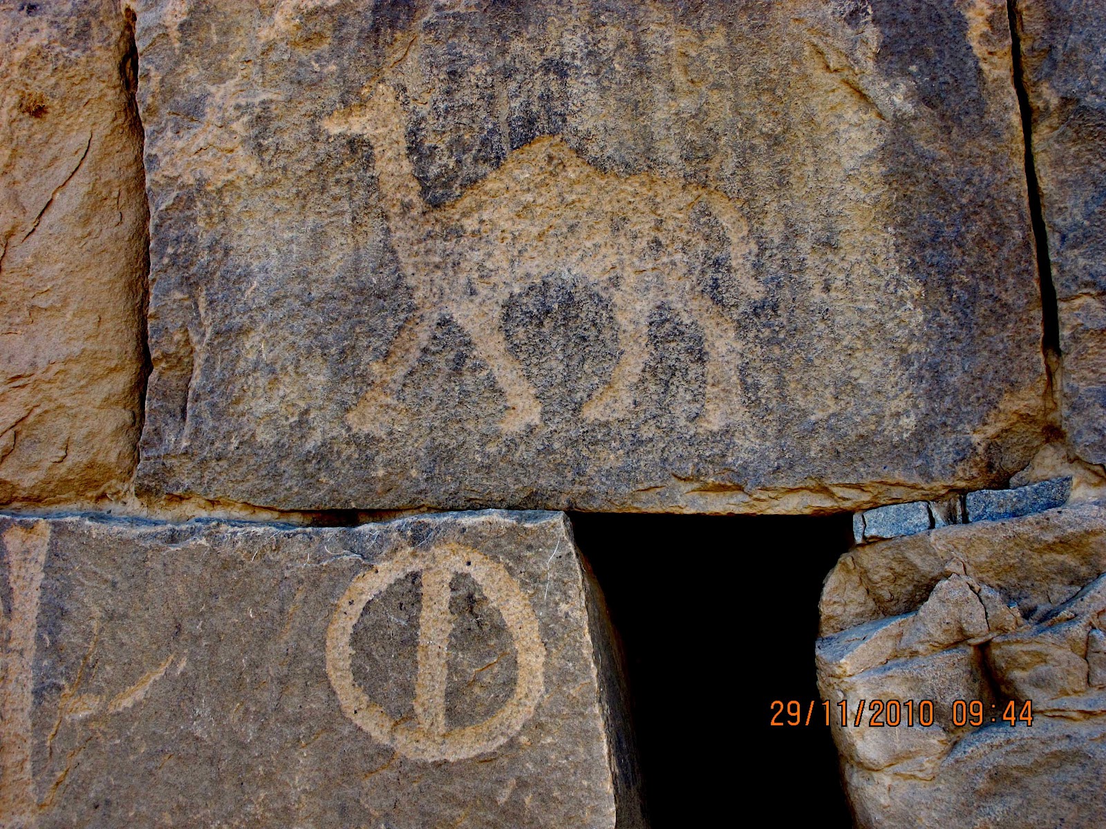
mountain lies to the western side and it includes rocky inscriptions and paintings.

      Location

      Za'abal Castle is located in Sakakah town center. From ANB branch ( on your left side), drive straight and on the first traffic light, turn left. Follow the road until you arrived on a T-intersection. Turn right and follow the road and after 3 to 4 stoplights you  will arrive in a crossing and you will also see a landscape of flowing water on your left side. Turn left (this road starts to descend) an you will finally found the castle on your left.

      Hotels and Restaurants

      There are 3-start and 5-star hotels in Sakakah, and it is the capital of Al Jouf Province. The best hotel in town is Al Nusl (5 star), rooms are superb and foods are great. There are also a number of 3 star hotels around Sakakah but be sure to have enough cash as SPAN services are sometimes not available. You will find Kudu in this town, Othaim and Panda are nearby this hotel. Banks and ATM's are available throghout Sakakah and Domat town. Al Nusl offers tourist guide services if required.


      Stairs leading to castle entrance.
       
       
      To visit the castle tower, you have to climb the renovated stairs and the original stairs dated hundred of years ago. Experience traveling back in time as you set your foot in this incredible structure...


       View of Sakakah from Castle Tower


       View of Castle Tower from the castle main entrance


       Tower of Za'abal Castle


                                                              Sunset view from Za'abal Castle


      Sisra Well

      Located 200 meters from Zaabal castle, the well dates back to Nabatean era (1st century BC to end of 1st century AD). The well has an opening in the East side to supply water to the farms. It's bore measure 8m x 9m and depth of 15 meters.


      Saudi Tourism (SCTA) office beside Sisra well and near Za'abal castle.
       
       
      Well, now that you had a glimpse of what Al Jouf province can offer, what are you waiting for..experience Saudi Arabia...visit Al Jouf Province..It's waiting for you to discover...........